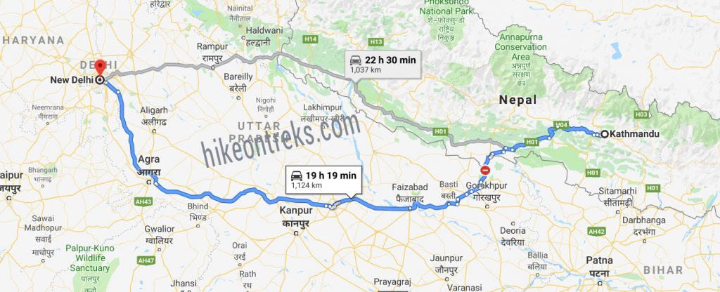
The Kathmandu to Delhi bus route map follows the trail crossing the major cities in Nepal like Chitwan, Nawalparsi and Butwal. Later, crossing the Sunawoli border the route crosses the places like Gorakhpur, Faizabad, Kanpur, Agra and finally to Delhi in India. The total distance of Kathmandu to Delhi bus route map is 1,124 Kilometers. Likewise, the total travel duration is around 23-28 Hours. Likewise, the Kathmandu to Delhi bus ticket is now available in Hike on travels at best price.
The Bus station in Nepal lies Near Pashupati Temple in Gaushala Kathmandu. Likewise in New Delhi, the bus station lies in North Delhi district (Majnu-ka-Tilla). Likewise, There are different pickup and drop stations in different places in India and Nepal. Similarly, The major bus stands lie at different major cities that fall under the route.
Kathmandu to Delhi Bus Stands in Nepal
Bus-park : Swayambhunath
| SN | Location | Pickup / Departure Time |
| 1 | Gaushala Near Pashupati Nath Temple | Hiace pickup around (8:00-8:15)AM |
| 2 | Chakrapath, Maharajgung | Hiace pickup around (8:30-8:45) AM |
| 3 | Gongabu Bus-park Near BG Mall | Hiace pickup around (9:00-9:15) AM |
| 4 | Balaju (Near Bhatbhateni) | Hiace pickup around (9:30-9:45) AM |
| 5 | Swayambhunath (our Bus-Park) | Bus departure around (10:00-10:15) AM |
| 6 | Kalanki near Baba Petrol Pump | 10:30 AM |
| 7 | Narayanghat | 2:30-3:00 PM |
| 8 | Sunawoli | 6:30-7:00 PM |
Bus Stand in Chitwan : Pulchowk, Narayanghat
Kathmandu to Delhi Bus Stands in India
Bus-Park : North Delhi district (Majnu-ka-Tilla)
Pick up points in Delhi : Paharganj, Gurudwara Bangla Sahib, Metro station Delhi
Bus stand in Agra : Ananda Bihar UP
Kathmandu to Delhi Bus Route Map Image
Recent Blogs
-
Best Time for Everest Base Camp Trek
19th July 2024 -
Ultimate Face Off: Manaslu Circuit Trek vs Tsum Valley Trek vs Larke Pass Trek
17th September 2023 -
Top 10 Best Treks in Nepal: The Ultimate Guide
6th August 2023 -
Trekking Essentials
8th November 2022 -
How I made it to Muktinath from Kathmandu
23rd December 2021 -
Kushma Bungee Package
19th November 2021


